Chapter 6: Geodesy, Coordinate Systems, and Map Projections

Geodesy gives coordinates their physical meaning. Without geodesy, latitude and longitude are just numbers. With geodesy, software can connect measurements, maps, satellite positions, survey control, and projected coordinates to Earth.
Companion visual reference: Spatial Data Structure Visual Atlas
Learning Goals
- Explain spheres, ellipsoids, geoids, datums, and coordinate reference systems.
- Know why map projections distort area, shape, distance, direction, or scale.
- Use CRS metadata safely in databases, files, APIs, and analysis.
- Test and debug projection-sensitive code.
Theory
Earth is irregular, so geospatial systems use models. A sphere is simple. An ellipsoid is better for global positioning. A geoid approximates mean sea level and matters for elevation. A datum anchors coordinates to Earth. A projected CRS converts curved coordinates into planar ones for mapping and measurement.
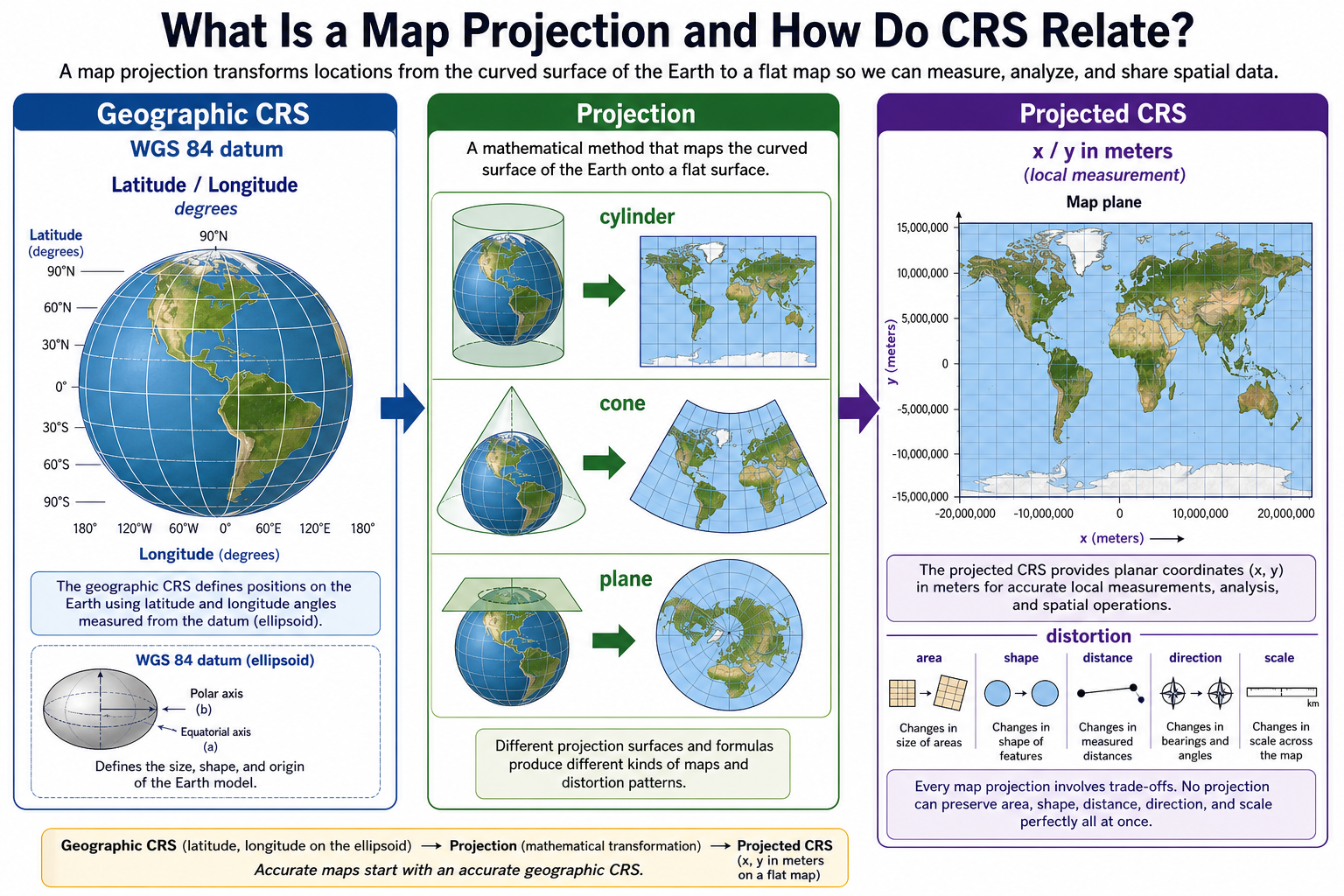
The most important hierarchy is:
Earth model + datum -> geographic CRS -> projection -> projected CRS
A geographic coordinate reference system describes positions on a curved Earth model using angular coordinates, usually latitude and longitude. WGS 84 latitude/longitude is the common example used by GPS and web APIs. A projected coordinate reference system starts from a geographic CRS and applies a mathematical projection to produce planar x/y coordinates, usually in meters or feet. In other words, projected coordinate systems do not replace geographic coordinate systems; they depend on them.
flowchart LR
    A[Datum and ellipsoid] --> B[Geographic CRS]
    B --> C[Latitude, longitude, ellipsoidal height]
    C --> D[Projection method]
    D --> E[Projected CRS]
    E --> F[x/y coordinates in meters or feet]
    B --> G[Geodesic measurement on ellipsoid]
    E --> H[Planar measurement in a chosen map plane]
Projection choice is task-specific. Equal-area projections preserve area. Conformal projections preserve local shape. Equidistant projections preserve selected distances. No projection preserves everything everywhere.
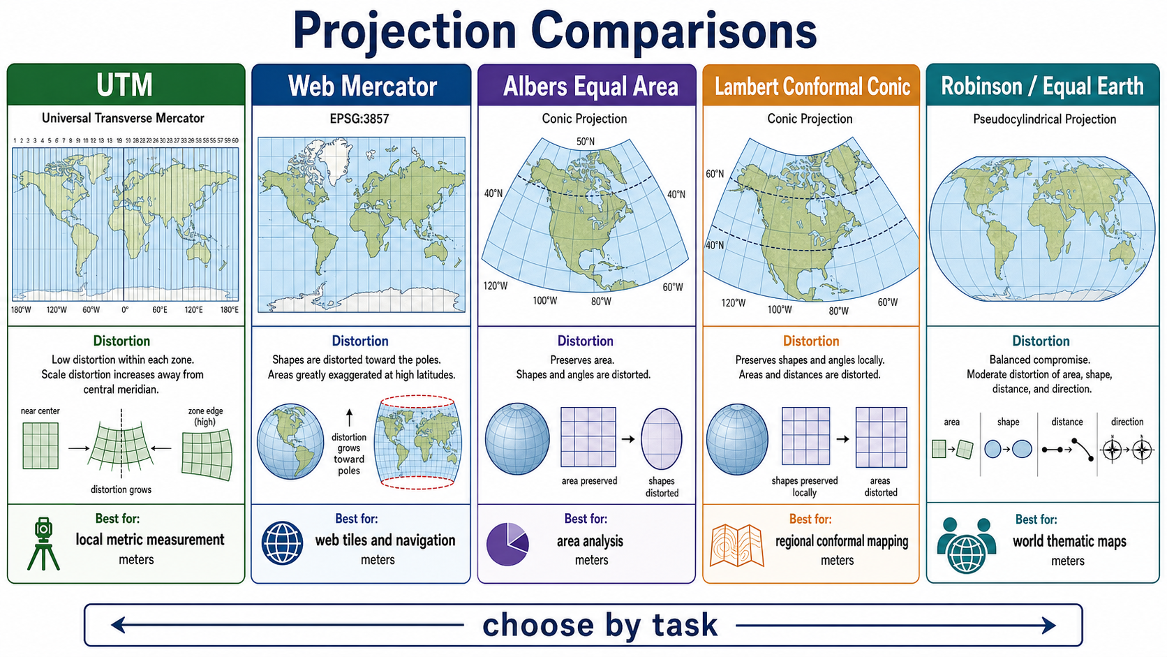
Common projection choices include:
| Projection or CRS family | Common use | What it preserves or optimizes | Important caution |
|---|---|---|---|
| Geographic CRS, such as WGS 84 / EPSG:4326 | Data exchange, GPS coordinates, global storage | Direct latitude/longitude reference to a datum | Degrees are angular units, not planar distance or area units. |
| UTM | Local and regional metric mapping | Low distortion inside each 6-degree zone | Bad for features crossing many zones or polar regions. |
| Web Mercator / EPSG:3857 | Web maps, slippy tiles, navigation display | Convenient square tile pyramid and local angle behavior | Severely exaggerates area toward the poles; poor for analysis. |
| State Plane and local engineering CRS | Surveying, parcels, infrastructure, engineering drawings | High local accuracy in a defined region | Must match the jurisdiction, datum, units, and epoch. |
| Albers Equal Area | Regional statistics, choropleths, area comparison | Area | Shapes, angles, and distances are distorted. |
| Lambert Conformal Conic | Mid-latitude regions, aeronautical charts, regional basemaps | Local shape and angles | Area and distance vary away from standard parallels. |
| Robinson / Equal Earth | World thematic maps | Balanced global appearance; Equal Earth preserves area | Not appropriate for precise measurement. |
The right projection is the one whose distortion pattern fits the job. A parcel tax system, a global climate dashboard, a mobile web map, and a statewide transportation map should not automatically use the same CRS.
GPS, GNSS, and Coordinate Reference Systems
GPS is part of a broader family called Global Navigation Satellite Systems (GNSS), which also includes systems such as Galileo, GLONASS, BeiDou, QZSS, and regional augmentation systems. A GNSS receiver estimates position by measuring signal timing from satellites with known orbits. The result is not just "a point"; it is a coordinate estimate tied to a reference frame, timestamp, uncertainty, and receiver processing method.
For most software teams, the common path looks like this:
flowchart LR
    A[GNSS satellites] --> B[Receiver timing measurements]
    B --> C[Position solution]
    C --> D[Latitude, longitude, height]
    D --> E[Geographic CRS such as WGS 84]
    E --> F[Transform or project for mapping and analysis]
    F --> G[UTM, State Plane, Web Mercator, local grid, or geodesic calculation]
GPS is closely related to CRS because receivers commonly output WGS 84 latitude, longitude, and ellipsoidal height. That is a geographic CRS-style coordinate, not a projected map coordinate. If a phone reports 39.7392, -104.9903, the application still needs to decide whether to:
- store the coordinate in WGS 84 for interchange;
- transform it to a local projected CRS for buffering, area, or engineering measurement;
- display it in Web Mercator tiles;
- compare it against a vertical datum or floor-level model; or
- preserve uncertainty, timestamp, source, and sensor metadata.
High-accuracy surveying may also use RTK, network RTK, PPP, ground control, geoid models, and time-dependent reference frames. These workflows are more precise, but they are also more sensitive to datum, epoch, antenna, correction service, and vertical reference metadata.
Location Technologies: Past, Mainstream, and Future
Positioning has always been a stack of technologies. Satellites are central today, but telecom, Wi-Fi, radio, inertial sensors, maps, and local infrastructure all matter.
| Era | Technologies | How they relate to CRS |
|---|---|---|
| Past foundations | Astronomical navigation, compass and chain surveying, triangulation networks, leveling, paper control monuments, LORAN, radio beacons, inertial navigation, early photogrammetry | Produced positions relative to local datums, survey control networks, charts, or navigation frames. Coordinate transformation was often a manual or agency-specific process. |
| Mainstream now | Multi-constellation GNSS, GPS modernization signals, SBAS, RTK, PPP, smartphone sensor fusion, cellular tower location, 4G/5G positioning, Wi-Fi positioning, Bluetooth beacons, UWB, IP geolocation, map matching | Devices estimate coordinates from many signals, then software must connect those measurements to WGS 84, local CRS, indoor reference frames, floor levels, or map-matched networks. |
| Emerging and future | LEO satellite PNT, resilient PNT backups, authenticated GNSS services, stronger anti-spoofing receivers, 5G Advanced and 6G positioning, Wi-Fi RTT improvements, UWB growth, visual/LiDAR SLAM, edge sensor fusion, quantum and improved inertial systems | Future systems will likely blend satellite, telecom, Wi-Fi, indoor, and onboard sensors. The CRS problem becomes multi-frame: outdoor geodetic coordinates, indoor maps, 3D building models, digital twins, and uncertainty models must agree. |
Telecom networks support positioning through cell identity, signal strength, timing advance, observed time difference, round-trip time, angle methods, and network-assisted GNSS. Wi-Fi positioning often uses access point databases, signal fingerprints, or round-trip timing. Satellite positioning provides global outdoor coverage and timing, but it can degrade indoors, underground, in urban canyons, under canopy, or during interference. Modern devices usually fuse these sources with accelerometers, gyroscopes, barometers, cameras, and maps.
Security, Privacy, and Resilient Positioning
Coordinates are operational data, but positioning systems are also security systems. GPS and GNSS provide timing for telecom networks, finance, power grids, transportation, emergency response, and cloud infrastructure. Location and timing failures can become cascading system failures.
Key risks include:
- Jamming: radio interference prevents receivers from using GNSS, cellular, Wi-Fi, or other signals.
- Spoofing: a receiver is misled into accepting false position or time signals.
- Replay and manipulation: stale or altered location observations are injected into a workflow.
- Over-trust: software treats a coordinate as exact even though it came from a noisy or weak signal source.
- Privacy leakage: telecom, Wi-Fi, app telemetry, and movement histories can reveal home, work, health, political, religious, or infrastructure-sensitive patterns.
- CRS confusion: attackers or bad data can exploit missing CRS, wrong axis order, wrong units, or mismatched vertical datums.
Security-minded geospatial software should record source technology, timestamp, CRS, estimated accuracy, altitude reference, transformation path, and confidence. Critical systems should cross-check independent sources, detect impossible jumps, reject stale timestamps, monitor GNSS health, and design graceful degradation when satellite, telecom, or Wi-Fi positioning is unavailable or suspect.
flowchart TD
    A[Location observation] --> B{Source}
    B -->|GNSS| C[Check satellite quality, dilution of precision, correction source]
    B -->|Telecom| D[Check cell/network method and expected accuracy]
    B -->|Wi-Fi / indoor| E[Check database age, floor model, and privacy policy]
    B -->|Manual / survey| F[Check datum, epoch, control, and method]
    C --> G[Validate CRS, timestamp, uncertainty]
    D --> G
    E --> G
    F --> G
    G --> H{Trusted enough for the task?}
    H -- Yes --> I[Use, store provenance, and project if needed]
    H -- No --> J[Flag, degrade, or request better measurement]
Research and Standards Foundations
Coordinate operations are not all the same. PROJ distinguishes projections, conversions, and transformations. A projection maps the curved Earth to a plane. A conversion changes coordinates without changing the reference frame. A transformation changes between reference frames or datums and can require grid files, Helmert transformations, vertical corrections, or time-dependent deformation models.
This distinction matters in software. A call to ST_Transform, pyproj.Transformer, or GDAL reprojection code may do more than "change units." It may apply a datum transformation whose accuracy depends on available grids, source metadata, and coordinate epoch. Production systems should record source CRS, target CRS, transformation method where practical, software/library version, and any known accuracy limits.
GPS.gov describes GPS as a U.S.-owned utility that provides positioning, navigation, and timing services through space, control, and user segments. Modern GPS is adding newer civil signals such as L2C, L5, and L1C, while resilient PNT guidance emphasizes that critical users should plan for disruption or manipulation of GPS signals. For engineers, the research lesson is that CRS correctness and PNT resilience belong together: a position is only useful when its reference frame, uncertainty, source, and trustworthiness are known.
Math
Important math includes angular coordinates, ellipsoidal parameters, geodesics, transformations, projection equations, scale factors, and vertical reference models. Distance and area on an ellipsoid differ from distance and area on a projected plane.
Key computation patterns:
planar distance:
d = sqrt((x2 - x1)^2 + (y2 - y1)^2)

haversine great-circle distance:
a = sin^2((lat2 - lat1) / 2)
  + cos(lat1) * cos(lat2) * sin^2((lon2 - lon1) / 2)
c = 2 * atan2(sqrt(a), sqrt(1 - a))
d = R * c

affine transform:
[x']   [a b tx] [x]
[y'] = [c d ty] [y]
[1 ]   [0 0 1 ] [1]
See also: Math and Algorithms Reference
Tools of the Trade
- EPSG registry.
- PROJ and pyproj.
- GDAL coordinate transformation tools.
- PostGIS
ST_Transform,ST_Distance, and geography types. - QGIS CRS inspector.
- GeographicLib.
- GNSS receivers, RTK/PPP correction services, geoid models, and survey control networks.
- Mobile positioning APIs, telecom location services, Wi-Fi positioning, Bluetooth/UWB indoor positioning, and inertial sensor fusion.
Examples of Real-World Solutions
- A city uses a local projected CRS for parcel area calculations.
- A global app uses WGS 84 for storage but projects data for local measurement.
- A drone survey uses ground control and vertical datum corrections.
- A shipping route uses geodesic paths rather than planar lines.
- A mobile emergency response system combines GNSS, cellular, Wi-Fi, barometer, and dispatchable address data to locate callers indoors and outdoors.
- A telecom operator uses GNSS timing, fiber timing, and resilient backups to keep network synchronization stable.
- A field asset inspection app stores GPS points in WGS 84, transforms them to a local engineering CRS for measurement, and records horizontal and vertical accuracy.
Working Practice Examples
- Reproject a dataset from WGS 84 to a local projected CRS and compare area results.
- Calculate distance between two cities using planar and geodesic methods.
- Identify a dataset with missing CRS metadata and write a risk note.
- Test whether your spatial API rejects or transforms unexpected CRS inputs.
- Compare the same city in Web Mercator, UTM, Albers Equal Area, and a local State Plane CRS. Explain which one you would use for display, distance, and area.
- Record a short phone GPS track and inspect timestamp, horizontal accuracy, altitude, and map-matched behavior.
- Design a schema for storing location observations from GNSS, telecom, Wi-Fi, and manual survey sources with CRS and uncertainty metadata.
- Write a security checklist for detecting spoofed, stale, or impossible location updates.
Common Failure Modes
- Calling EPSG:4326 "x/y" without considering axis and units.
- Measuring area in degrees.
- Mixing datums silently.
- Ignoring vertical datums.
- Choosing Web Mercator for serious area analysis.
- Treating GPS coordinates as exact ground truth.
- Dropping timestamp, accuracy, altitude reference, or source technology from location records.
- Projecting latitude/longitude into a local CRS without confirming datum and axis order.
- Combining indoor Wi-Fi positions, floor levels, GPS heights, and building models without a shared vertical reference.
- Building critical workflows that fail completely when GNSS is jammed, spoofed, or unavailable.
Works Cited
"EPSG Geodetic Parameter Dataset." EPSG.io, https://epsg.io/. Accessed 9 May 2026.
"GPS.gov: GPS Overview." GPS.gov, National Coordination Office for Space-Based Positioning, Navigation, and Timing, https://www.gps.gov/systems/gps/. Accessed 12 May 2026.
"GPS.gov: GPS Modernization." GPS.gov, National Coordination Office for Space-Based Positioning, Navigation, and Timing, https://www.gps.gov/gps-modernization. Accessed 12 May 2026.
"GPS.gov: New Civil Signals." GPS.gov, National Coordination Office for Space-Based Positioning, Navigation, and Timing, https://www.gps.gov/new-civil-signals. Accessed 12 May 2026.
"GPS.gov: Resilience Through Responsible Use of PNT." GPS.gov, National Coordination Office for Space-Based Positioning, Navigation, and Timing, https://www.gps.gov/index.php/resilience-through-responsible-use-pnt. Accessed 12 May 2026.
"GPS.gov: Information About GPS Jamming." GPS.gov, National Coordination Office for Space-Based Positioning, Navigation, and Timing, https://www.gps.gov/information-about-gps-jamming. Accessed 12 May 2026.
"Wireless E911 Location Accuracy Requirements." Federal Communications Commission, 6 Mar. 2025, https://docs.fcc.gov/public/attachments/DOC-410028A1.pdf. Accessed 12 May 2026.
"Wireless E911 Location Accuracy Requirements: Small Entity Compliance Guide." Federal Communications Commission, https://docs.fcc.gov/public/attachments/DA-20-458A1.pdf. Accessed 12 May 2026.
Iliffe, Jonathan, and Roger Lott. Datums and Map Projections for Remote Sensing, GIS and Surveying. 2nd ed., Whittles Publishing, 2008.
"Coordinate Operations." PROJ, https://proj.org/en/stable/operations/index.html. Accessed 9 May 2026.
"Transformations." PROJ, https://proj.org/en/stable/operations/transformations/index.html. Accessed 9 May 2026.
"PROJ." PROJ Contributors, https://proj.org/. Accessed 9 May 2026.
Snyder, John P. Map Projections: A Working Manual. U.S. Geological Survey Professional Paper 1395, 1987.
![]()